LittleNavMap

Playrec

Frederic
PILOTE DE CHASSE
Messages
6 225
Réactions
2 323
Points
1 290
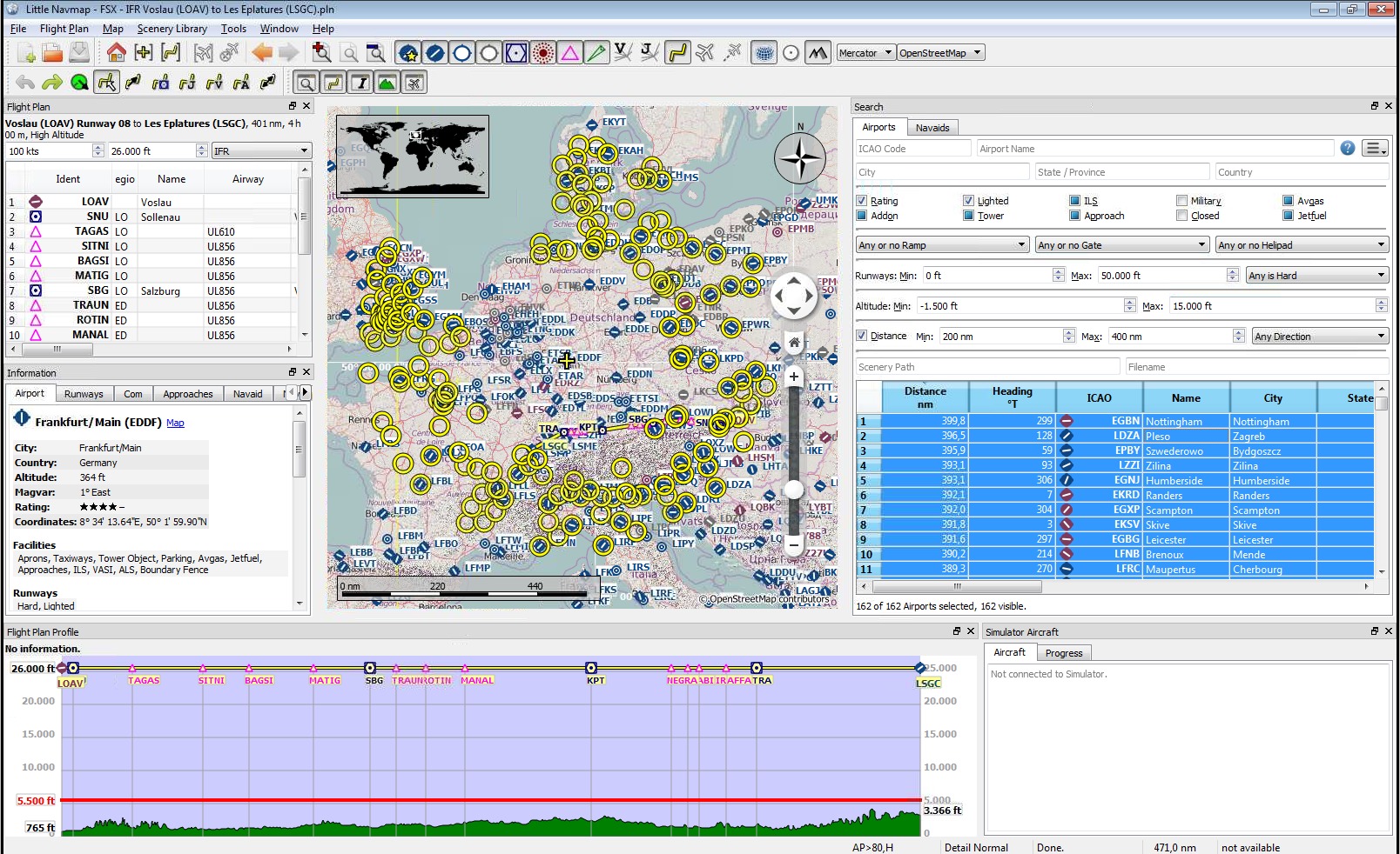
LittleNavMap v2.6.5 , free open source flight planner, navigation tool, moving map, airport search and airport information system .

langues : anglais , français, allemand , espagnol , italien , portugais , brésilien , chinois , néerlandais , ...
Linux - Macos - Windows

littlenavmap_complexsearch.jpg
 
Dernière édition:
Tu parles allemand ?

Le mien en Français ou en anglais qui ne dérange pas non plus ..
si tu veux d'autre map fait moi le savoir j'ai la collection
le chemin se trouve ici : C:\Users\MOI\LNM\LittleNavmap-win-2.6.6\Little Navmap\data\maps\earth

LNM.JPG
 
Dernière édition:
LittleNavMap v2.6.11

## Changes from 2.6.10 to 2.6.11
### Weather
* Fixed `Error downloading or reading wind data` issue. Adapted URL for winds aloft download to
NOAA changes and added `atmos` as directory. #623
* Now suppressing wind and other downloads with log warning message if URLs are empty. #623
* New decompression methods to speed up weather and track downloads.
* Now showing airport weather symbols on higher zoom levels. Avoiding simple line on wind barb
which can be confused with low wind.
### Flight Plans
* Corrected approach identifier in FLP flight plan export and loading for Aerosoft aircraft. Now
using ARINC identifier for approaches and ignoring transitions of type `VECTOR`. Adapted changed
keywords in file for CRJ. Problems still appear when loading flight plans into the aircraft. This
will be fixed in one of the next updates.
* Added extra entry for Aerosoft MSFS CRJ in multi export to avoid loading issues because of a
too long file name.
* Added patch by Slawek Mikula to support loading of Aviamaps flight plans. #616
* Exporting online network flight plan files from menu now correctly remembers last used folder for
each format.
### Other
* Adjustments to drawing. ILS, online aircraft and AI aircraft are now shown at higher zoom levels.
* Added support for new VATSIM JSON version 3 data feed. Better update rate for online networks is now
one minute for VATSIM and PilotEdge and two minutes for IVAO. Allowing centers and clients (VATSIM
prefile) without coordinates now throughout program. Keep in mind that the real center boundaries are
not depicted yet. #606
* MSFS: Now ignoring invalid content types like `Unknown` in MSFS `manifest.json` file which are
often set wrongly by add-on developers. This kept add-on airports from showing up.
* Fixed issue where userdata CSV backup files could not be loaded and had to be manually
corrected before import.
* Updates for detection of military airports and name capitalization.
* More small user interface corrections.
 
vue j'avions installé et remis mes google map à l'intérieur du Data ..
 
Vous savez si on peut modifier un waypoint quand on créer son propre plan de vol ? J'ai cherché mais pas trouvé.
 
Vous savez si on peut modifier un waypoint quand on créer son propre plan de vol ? J'ai cherché mais pas trouvé.
Salut, salut
tu veux dire après avoir enregistré ton PDV , modifier un waypoint pour en choisir un autre .... puis ré enregistrer ?
si oui avec la fonction éditer : visuellement tu étires ton segment vers le nouveau point que tu veux relier... puis tu réenregistres

RoRo ;)
 
Salut Roro,

Quand je ne laisse pas le logiciel calculer le plan de vol, il me place des WP1, WP2...j'aimerais changer par autre chose.
 
Salut Windy !

il me place des WP1, WP2...j'aimerais changer par autre chose
autre chose = WP différent ?!?

LittleNavMap est un logiciel complet capable de faire un paquet de trucs , pas un vulgaire "addon" ...

Si tu prends le temps de lire le manuel (en français) au fur et à mesure de tes besoins , il deviendra vite indispensable quelque soit l'avion ou la taille de du "cockpit" !

 
Avec Flight plan, je mets du texte dans l'ID ou j'édite le le .pln et je remplace les WP1, WP2 par ce que je souhaite
 
Merci Fred, mais je n'ai pas le temps de lire le manuel. Fab a mieux répondu à mes attentes ;G)
 

@Playrec

Merci à toi de m'avoir fait découvrir ce logiciel au travers de ce post.;)

Il est aujourd'hui monté dans mon environnement simulateur car je le trouve très chouette et très pratique.
:)
 
le 4ème onglet sur la barre des tâches inférieur *** Activer ou désactiver le mode édition du plan de vol sur la carte ***

là tu peux éditer tes Way Points ..
tu cliques dessus une fois finit tu re-cliques dessus pour désactiver . ne fait pas trop rapidement pour pas faire des zig et des zag ....

Patou
 

LittleNavMap v2.6.13

Important Notes

  • You have to update/reinstall Little Navconnect and Little Xpconnect if you use these since the data protocol has changed. This version is compatible with Little Navconnect 2.6.11 and Little Xpconnect 1.0.24 or newer.
  • Aircraft label settings are reset back to default. Adjust these in the options dialog on page Map Display 2.
  • All MSFS scenery library related changes need at least MSFS version 1.16.2 .
  • MSFS users need to reload the scenery library to new features like SID and STAR.
  • Do not use the scenery library mode Do not use Navigraph Database if you have the Navigraph udpate installed. You will see errors in procedures. Instead update the scenery database of Little Navmap using the Navigraph FMS Data Manager.

Changes from 2.6.11 to 2.6.13

Version 2.6.12.beta was an unofficial beta release.

Flight Plans

  • Corrected loading and saving of GPX tracks. Now also saving timestamps and considering disconnected trail segments. A flight where the aircraft was moved or warped during flight results in a straight line connecting the two segments. Changing aircraft, restarting the simulator or Little Navmap results in disconnected trail segments.
  • Fixed issue causing error messages on flight plan elevation profile calculation if destination airport is below sea level and an approach procedure is used.
  • Flight cruise altitude was set wrongly after calculating route with metric altitude units.
  • Now omitting visual reporting points (like VP123) and other obscure numbered waypoints from route calculation. Also ignoring half degree points like H5711 in north atlantic now. Simplified and optimized loading of routing network.
  • Fixed issue where a flight plan calculation resulted in not optimal routes. This happened when a nearby navaid connected to the airway system could not be found.

Flight Plan Export

  • Enabled departure parking position for MSFS flight plan export and import. Enabled check for parking position for MSFS export which shows a warning if starting on a runway. You can also set a fuel pad as starting position but note that runways and helipads as starting positions will be ignored by MSFS.
  • More relaxed user waypoint naming conventions for MSFS. Now allowing more special characters.
  • Corrected Aerosoft CRJ flight plan export as far as possible. Now exporting a list of waypoints instead of airway routes for MSFS CRJ to minimize issues when loading plan in aircraft. Adapted changed keywords in .flp file and compressing airway segments now. #632
  • Added export of modified PLN format for Integrated Simavionics / ISG devices and gauges.
  • Export option for MSFS PMS50 GTN750 Garmin added. This export saves the flight plan using a fixed filename fpl.pln.
  • Now always adding procedure entry and exit waypoints for flight plan export formats not supporting procedures like FSX/P3D PLN. User can an additional waypoint in the simulator if needed.
  • Corrected default flight plan pattern to use departure and destination ident if flight plan pattern is empty. Used departure airport ident wrongly before.
  • Changes to allow updates for new export formats.
  • Now clearing invalid procedures (red error message below flight plan table) before saving LNMPLN. Reloading a saved LNMPLN clears any error messages now.

Procedures and Scenery Library

  • Now fully recognizing SID and STAR from MSFS scenery library. Many thanks to icykoneko for implementing this. #649
  • Adapted loading of approach procedures and some airport structures to new MSFS changes since 1.16.2. This fixes the issue of empty and not selectable approaches in the procedure tab.
  • Constant turn radius legs in procedures are now correctly depicted for MSFS.
  • Fixed issue where some navaids did not get airport ident assigned if in different BGL file.
  • Other improvements for procedure drawing.
  • Added speed limit for MSFS procedure legs.
  • Now checking all MSFS procedures before saving in the database. A warning will be logged and the procedure will be omitted if not valid.
  • Now omitting closed dummy airport structures having no runways and no start positions which are used by MSFS as POIs.
  • Fixed issue where an error was shown when loading Library.xml files from add-on aircraft.
  • Library.xml files are now considered when excluding folders from loading.
  • Removed exception for invalid files in X-Plane CIFP path. Now simply writing a warning to the log file.

Map

  • Fixed issue where tooltips and click regions for route preview were wrongly active when showing more than on logbook entry highlighted.
  • Added new airspace types MCTR, TRSA and GCA where GCAis for unknown and general types. #607
  • Function Center map on aircraft and next flight plan waypoint now uses defined box for aircraft and waypoint to avoid aircraft or next waypoint leaving screen space. More improvements to aircraft centering to avoid permanent updates or hanging view.
  • Corrected flight plan editing on map which could cause various issues if editing near a missed approach which is hidden on the map.
  • Removed wrongly drawn procedure point underlay (like overfly indication) from intercept point for legs.
  • Now updating online centers (transceivers) in VATSIM network every five minutes. Fixes issue where user had to restart LNM to update VATSIM centers.
 
LittleNavMap v2.6.14

11 juillet 2021
LNM v2.6.14 contains bug fixes, small user interface improvements and support for the new IVAO interface which allows higher update rates .
 
LittleNavMap v2.6.15

This version contains bug fixes, small user interface improvements, support for MSFS scenery library changes and a new airport ident search for X-Plane
 
LittleNavMap v2.6.16

This version fixes flight plan issues with X-Plane as well as flight plan export and printing issues.

X-Plane flight plan export and loading #741

  • Now falling back to DEP/DES keywords in X-Plane FMS flight plan files. These keywords denote departure or destination as a waypoint or a not identifiable airport opposed to ADEP/ADES. This avoids loading issues in X-Plane FMS and third party tools. Flight plans should be loadable in X-Plane FMS and GPS in any case. The conditions for this case are below:
    • Airport ident is longer than four characters. Example: White Lake (XC0004).
    • Airport has ICAO and this does not match internal id. Example: Torres with official ICAO id SSTE using internal ident of SBTR.
    • Airport has no ICAO but FAA code which does not match the internal id. Example: Red Lion with FAA code JY73 using internal ident of N73.
    • Airport has neither of above but a local code which does not match internal. Example: Edmonton Cooking Lake having local code of CEZ3 and internal X-Plane ident EZ3.
  • Now truncating all X-Plane airport idents to six characters. Also the ones used in intermediate waypoints.
  • Enabled loading of X-Plane FMS plans with truncated airport ids.

General​

  • Added airport elevation to tab Runways and airport transition altitude in tab Weather in information window.
  • Fixed issues with flight plan and waypoint remarks being truncated when saving plan as HTML, printing plan or copying plan as CSV (Ctrl+C in table).
  • Fixed issues when copying CSV text to clipboard in flight plan table and search result tables (Ctrl+Cin table). Wrong columns were copied into the CSV text if columns in the table were reordered.
  • Added missing flight plan remarks field to HTML export and print.
  • Table columns which are shrinked to minimum width are now excluded from export to HTML and CSV.
  • Fixed issue where the wrong flight plan columns were printed or exported to HTML or columns were missing. This happened if the user rearranged the flight plan table columns by moving the headers around.
  • Small corrections to options dialog text, aircraft labels on the map (TCAS vs XPDR) and airport labels on the map.
  • More tolerance for finding airports when loading flight plans. Trying all available internal and official ids (ICAO, FAA, IATA and local) now.
  • Now also showing ILS frequency for final approach in flight plan table for circling as well as IGS, LDA, LOC and SDF approaches if navaid is present.
 
Bonjour et bravo pour ce planificateur.
J'aime particulièrement la possibilité d'intégrer les AIRACS (abonné Navigraph) et d'adapter la base de données en fonction du simulateur choisi pour le vol.

Pour éditer les WPn, depuis le plan de vol (clic droit sur le nom dans la colonne à gauche), on peut modifier le nom du point, corriger éventuellement les coordonnées et ajouter un commentaire.
L'insertion des SID, STAR et Approches dans le plan de vol est très pratique (attention, la suppression de l'un des points entraîne la suppression de toute la procédure : pratique pour changer de procédure au lieu d'être obligé de supprimer les points un à un)

Bons vols à tous
 
Y a un truc que je comprend pas chez Alex

avec Flight share on voit tout les avions connectés autour de nous en MSFS2020
Et dans LNM toujours pas rétabli ..?
Fonctionne pour les P3D sans Problème . XPlane je sais pas .
 
Bonjour,

A priori c'est MSFS qui ne remonte pas les infos des joueurs MSFS réels via simconnect. Par contre on voit les avions vatsim ou ivao (enfin pas sûr pour ivao, ça fait un moment que j'ai pas volé avec).
 
LittleNavMap v2.6.17 (18 octobre 2021)
This release adapts Little Navmap to the latest MSFS changes that cause crashes when loading the scenery library, as well as other fixes and improvements that also affect X-Plane.

Changes from 2.6.16 to 2.6.17:

MSFS
• Fixed crashes when loading scenery library of MSFS SU6. #799
• Corrected MSFS airport detection. Now ignoring airport closed flag which removes many POI wrongly detected as airports.
• Reduced warnings for unknown BGL records to avoid flooding the log with messages and crashing when reading scenery.
Map
• Limited minimum detail level to -2 to avoid confusion about missing map features when user selects a too low value. Now resetting details to default on update.
• Fixed issue where runway offset markings were not visible on unknown runway surfaces like when using scenery library mode Use Navigraph for all Features.
• Corrected drawing for logbook entries where departure or destination airport could not be found in the scenery library database.
Options
• Changed IVAO weather URL to use HTTPS (secure connection). The URL is now reset to the new default on first startup.
• Fixed issue where AI and user aircraft tooltip settings were not restored in options.
Flight Plan
• Corrected flight plan calculation using radio navaids. Selected navaids were too close in some cases. Example: PAYA MDO ODK CDB ELF DUT PADK where CDB and ELF are too close resulting in zig-zag routing.
• Added heading for departure parking position to LNMPLN flight plan format.
• Adjusted cost factor for flight plan calculation to avoid direct calculation (no airways at all) on the last two ticks of the slider. Default value for slider after installation is not centered.
• Fixed issues where departure position type (runway, parking, helipad or airport) was not saved in LNMPLN after changing start position to a runway or assigning departure airport. Departure position type now set correctly to runway after assigning a runway automatically.
Logbook Search
• Fixed broken search for departure and destination airport in logbook.
• Disabled not working airport filters in logbook search context menu (Filter by ... in context menu). These will be enabled again in a later version.
• X-Plane: Fixed several issues where an airport using official ids (ICAO, FAA, IATA or local) was not found in logbook context menu, logbook edit dialog and information display for log entries.
Other and User Interface
• Fixed issue where an internal cache gave wrong results which caused random wrong airport assignments when working with flight plans or after switching scenery library databases.
• Removed slow down in internal airport queries when searching by official codes. This caused short freezes when clicking on an airport for information in some cases.
• Fixed several issues where airports were wrongly identified as X-Plane airports. Corrected display of airport ids.
• Fixed issue where a X-Plane was still wrongly detected while using scenery library mode Use Navigraph for all Features.
• X-Plane: Adjusted display options for official airport codes. IATA is now used before internal ident in all cases. Route description now shows IATA code as well if available.
• Adjustments to flight plan and aircraft centering when getting close to ground while flying. Now avoiding too close zoom.
• Added Pilot Nav to airport link list.
• Removed Work offline option in file menu since it is of limited use and causes too many problems if users check this inadvertently.
• Fixed bug with wrong airspace assignment for class F and G when reading OpenAir files. #797
• Better coordinate parsing. Removing separators |, ;, _ and : for latitude and longitude now.
• Fixed several typos in user interface and more small user interface improvements.
Build and Development
• Now using Qt libraries 5.15.2.
• Changed build to use OpenSSL library provided by the Qt installer on Windows.
• Updated flight plan schema file lnmpln.xsd and LNMPLN file format documentation in the user manual.
 
Bonsoir tout le monde

Bon suis surement ignare dans l'utilisation de ce soft et je l'avoue j'ai pas lu la doc qui en plus est en Français ce qui pour moi est le summum mais promis je vais le faire. Quoiqu'il en soit je m'en sert avec msfs et je trouve ça super, sauf que souvent le PLV que j'ai fais avec LNM ne me donne pas le même tracé quand je le charge sur MSFS. Exemple LFRK départ piste 31 vers LFPN arrivée en 25R et LFRK départ piste 31 vers LFOB arrivée en piste 30.
L'inverse est également vrai si je fais ces PLV en direct sur MSFS et que je les enregistre puis les charge sur LNM dernière version 2.6.17 c'est pareil tracé complètement différent.
Engueulez moi si vous voulez traitez moi de .... mais dites moi pourquoi?
Amicalement
Pierre
 
Probablement parce que LNM et MSFS n'ont pas la même version d'airac
(EST CE QUE TON DOSSIER COMMUNITY EST VIDE?!? Hum... Je plaisante mais t'avais l'air d'avoir envie de te faire engueuler ;G) )
 
Bonsoir à toutes et à tous,
Depuis quelques jours dans LNM j'ai ces messages (voir image dans le cercle rouge), j'ai fouiné cherché je ne trouve pas pourquoi?
amitiés
Pierre
lnm.jpg
 
Merci Neptune mais ça ne fonctionne pas, j'en ai un qui fonctionne sur un autre PC j'essaie avec une copie
 
Retour
Haut